Magnitude 7.7 earthquake off Flores: the tsunami alert crosses the Pacific, and the death toll ranges from 1 to 20
published on
countries
sources
articles
Measured with the previous method (distance between texts), on a different scale.
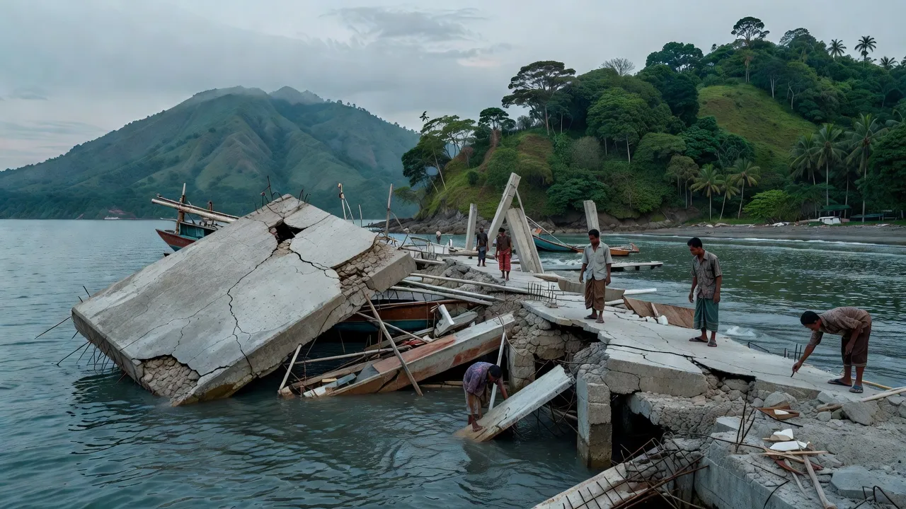
A 7.7 magnitude earthquake struck off the coast of Flores Island in Indonesia's East Nusa Tenggara province on Saturday, August 15, 2026, at a depth of about 10 kilometers, according to the USGS. Indonesia's BMKG agency issued a tsunami alert minutes after the quake, which was later lifted. The port terminal in Maumere collapsed on passengers boarding, and dozens of aftershocks were recorded, with the alert relayed as far as the South American Pacific coast.
The human toll is not yet stabilized, ranging from one to twenty deaths, depending on whether the national agency, the provincial governor, or local rescue teams are cited.
The terminal collapsed on passengers boarding a ferry; the video was verified by Reuters.
The BNPB identified Bernadus Muda, from Adonara, and Maria Diana Meliana, from Sikka.
The Peruvian navy issued a warning bulletin fifteen minutes after the quake, thousands of kilometers away.
Key figures
- 68 kmDistance from the epicenter northwest of Ende city, at a depth of 10 kilometers (USGS)1 source · ABC News
- 0.94 mHeight of the highest wave measured on the coast of Ende before the alert was lifted1 source · Antara News
What the comparison reveals
Common ground and differences in coverage across the media analysed.
What the media report in common
An earthquake struck off the coast of Flores Island in Indonesia's East Nusa Tenggara province on Saturday, August 15, in the morning, at a depth of about ten kilometers.
The Indonesian BMKG issued a tsunami alert a few minutes after the quake, before lifting it; the highest wave measured reached 0.94 meters on the coast of Ende.
The port terminal in Maumere collapsed on passengers who were boarding, in a sequence captured and verified on video.
Where media coverage diverges
A human toll that varies from 1 to 20 deaths depending on the administrative level consulted
Four different death tolls coexist in the corpus, each corresponding to a different level of the Indonesian state. The national disaster management agency (BNPB) reports one to two deaths. The governor of the province, Emanuel Melkiades Laka Lena, reports five deaths. The local relief official, Fathur Rahman, cited by the AFP, reports twenty deaths. No media outlet confronts these numbers with their institutional source; most choose one and attribute it correctly, without reporting the existence of the others.
Coverage aligned with this reading
Coverage that diverges
Magnitude and epicenter: two competing official measurements
The USGS reports a magnitude of 7.7 and an epicenter 68 kilometers north-northwest of Ende. Geoscience Australia measures 7.8. The Indonesian BMKG situates the epicenter near Mbay, in the Nagekeo regency, and retains a depth of fifteen kilometers, whereas the USGS retains ten. Media outlets repeat the institution of their choice without ever comparing it.
The covered event is not the same on either side of the Pacific
For South American media outlets, the subject is the triggering and then the lifting of an alert on their own coasts, thousands of kilometers from the epicenter: a local non-catastrophe. For the Indonesian media outlet, it's about named deaths, a collapsed port, and an evacuated population. For European and North American media outlets, it's an exercise in verifying the toll from a distance.
This grouping describes the publications analysed, not the position of these countries’ populations or of their governments.
Blind spots
What the coverage of each country leaves aside, while others put it forward.
 China
China- higher casualty reports from international agencies
 United Kingdom
- transpacific alert chain triggered in South America
 Peru
Peru- extent of damage and human toll in Indonesia
How each country reads it
Preview: 3 of 14 media perspectives. Syntheses of the media analysed — not direct quotations. Method & limitations
 South Korea
Seoul is reporting two conflicting human tolls — five deaths according to the AP, twenty according to the AFP — without reconciling them, indicating coverage reliant on wire reports rather than its own reporting.
2 sources · View sources
 Argentina
Buenos Aires is faced with two conflicting human tolls from the Indonesian earthquake, with no tsunami alert issued for its own Atlantic coast.
2 sources · View sources
 Australia
Canberra is grappling with a conflicting human toll report from its immediate Indonesian neighbor, while ruling out any tsunami risk for its own coastlines.
3 sources · View sources
The full text, country by country
South Korea
DOMINANT ANGLE
Seoul is reporting two conflicting human tolls — five deaths according to the AP, twenty according to the AFP — without reconciling them, indicating coverage reliant on wire reports rather than its own reporting.
ANALYSIS
Seoul, August 15, 2026.
Argentina
DOMINANT ANGLE
Buenos Aires is faced with two conflicting human tolls from the Indonesian earthquake, with no tsunami alert issued for its own Atlantic coast.
ANALYSIS
Buenos Aires, August 15, 2026.
Australia
DOMINANT ANGLE
Canberra is grappling with a conflicting human toll report from its immediate Indonesian neighbor, while ruling out any tsunami risk for its own coastlines.
ANALYSIS
Canberra, August 15, 2026.
 Bangladesh
DOMINANT ANGLE
Dhaka reports two conflicting human tolls from the Flores earthquake, with 20 deaths according to a relief official cited by AFP and five deaths according to the provincial governor, without verifying the sources.
ANALYSIS
Dhaka, August 15, 2026.
 Canada
DOMINANT ANGLE
Canada reports a varying human toll, with the provincial governor citing five deaths and Indonesia's national agency confirming only one.
ANALYSIS
Ottawa, August 15, 2026.
China
DOMINANT ANGLE
Beijing is sticking to the official human toll released by its state-run media outlet CGTN, rather than the higher figure reported by Hong Kong's South China Morning Post.
ANALYSIS
Beijing, August 15, 2026.
 Ecuador
DOMINANT ANGLE
Quito has initiated an analysis by INOCAR of its own coast, treating the Indonesian earthquake as a test of its transpacific alert chain rather than a direct threat.
ANALYSIS
Quito, August 15, 2026.
 Indonesia
DOMINANT ANGLE
Indonesia assesses the human toll in Maumere — two named fatalities, a collapsed port — as the Indonesian press also notes how foreign media are reporting on its own earthquake.
ANALYSIS
Jakarta, August 15, 2026.
 Mexico
DOMINANT ANGLE
Mexico City draws a parallel between the Indonesian earthquake with a magnitude of 7.7 and its own seismic history, without issuing a warning for its Pacific coast.
ANALYSIS
Mexico, August 15, 2026.
 Malaysia
DOMINANT ANGLE
Kuala Lumpur is updating its casualty toll by the hour, with the death count jumping from two to twenty, according to AFP reports relayed by Malaysian media.
ANALYSIS
Kuala Lumpur, August 15, 2026.
Peru
DOMINANT ANGLE
Lima activated its entire tsunami alert chain in response to an earthquake that occurred thousands of kilometers away, before ruling it out within a few hours.
ANALYSIS
Lima, August 15, 2026.
 Pakistan
DOMINANT ANGLE
Islamabad is reporting two to three competing human tolls from the Flores earthquake, with the Pakistani press reconstructing the event through AFP and Reuters dispatches rather than direct coverage.
ANALYSIS
Islamabad, August 15, 2026.
United Kingdom
DOMINANT ANGLE
London is closely examining the discrepancy between the provincial and national death tolls from the Indonesian earthquake, opting to verify through imagery rather than rush to a specific number.
ANALYSIS
London, August 15, 2026.
 United States
DOMINANT ANGLE
The United States anchors the global narrative with scientific measurements: the USGS provides magnitude, epicenter, and depth, relayed as far as South America.
ANALYSIS
Washington, August 15, 2026.
Explore every perspective on this subject across 14 countries.
Compare viewpoints and see where they diverge.